
High-Altitude Disaster Cascades Require Cross-Border Early Warning Innovation
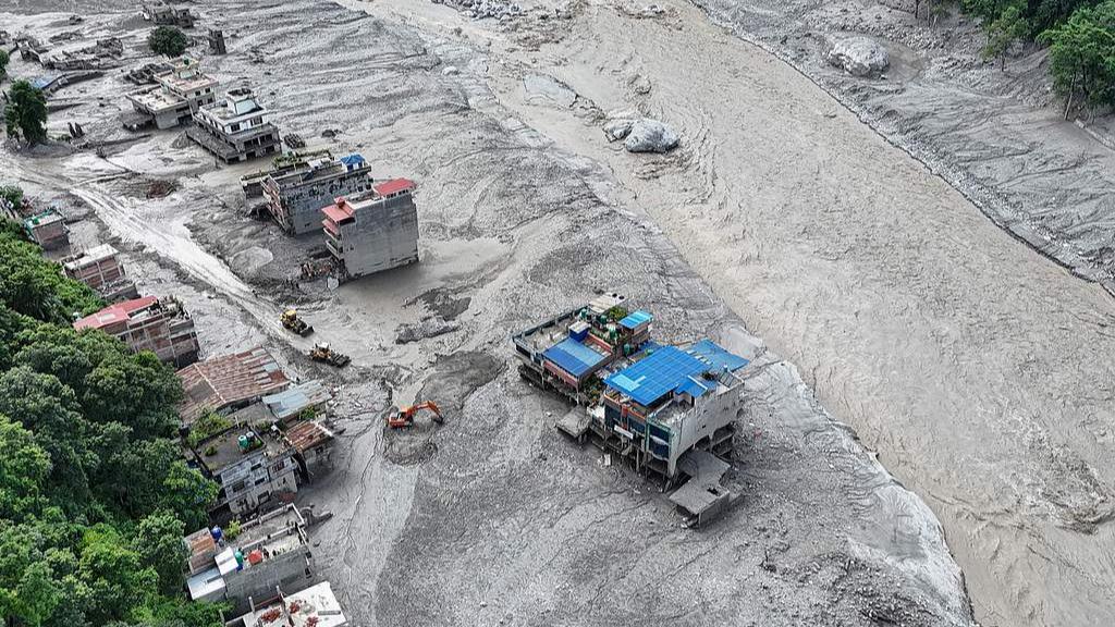
When natural hazards cross national borders with devastating velocity, the traditional boundaries of regional disaster management are rendered obsolete. The recent catastrophe at Gyirong Port, triggered by a massive high-altitude ice avalanche upstream in Nepal that evolved into a high-speed debris flow and subsequent mudslide, illustrates just how interconnected fragile mountain ecosystems truly are. According to the Ministry of Natural Resources, the disaster prompted the immediate activation of a Level-II geological disaster emergency response at 3 p.m. on Wednesday, deploying specialized working groups to coordinate rescue operations. Behind these administrative protocols lies a stark physical reality: thousands of tons of collapsing glacial ice scraped up unstable moraine deposits across the valley, transforming a remote upstream slope failure into a high-velocity destructive surge hitting populated border infrastructure.
Analyzing the mechanics of this event reveals the alarming speed at which cryospheric hazards escalate. As senior engineer Guo Zhaocheng from the China Aero Geophysical Survey and Remote Sensing Center noted through high-resolution remote sensing analysis, the sequence began on the upper reaches of Cuojian, a tributary of the Donglin Zangbo River. When high-altitude ice masses detach, they do not merely melt; they act as hydraulic bulldozers. In steep alpine terrain with gradients often exceeding 40 degrees and flow velocities that can surpass 15 meters per second, debris flows bulk up rapidly, entraining up to 70% solid sediment by volume. This volumetric amplification multiplies the destructive kinetic energy exponentially, turning a localized hydrological anomaly into a multi-million-dollar infrastructure crisis that overwhelms standard drainage coefficients and concrete retaining walls designed for typical seasonal rainfall.
Mitigating future cross-border geological risks demands an evolution in technological integration and regional resilience strategies. We must move beyond reactive emergency deployments and invest heavily in automated transboundary monitoring networks. Implementing real-time seismic acoustic sensors, high-frequency satellite radar interferometry, and automated upstream water level gauges can reduce warning latency from hours to mere minutes, providing a critical window for evacuation along narrow valley corridors like the Donglin Zangbo basin. Furthermore, structural defenses must be upgraded to withstand higher dynamic impact loads, incorporating flexible ring-net barriers and tiered check dams engineered to dissipate the kinetic energy of high-density debris surges. As global climate shifts continue to destabilize high-altitude permafrost and glacial lakes, strengthening international data-sharing frameworks—much like the cooperative reporting seen through People's Daily—will remain vital for protecting border communities and maintaining secure trade pathways in high-risk seismic zones.
News source: https://peoplesdaily.pdnews.cn/china/er/30053031911